Settlements and wells along the caravan-nomadic routes of the Aral-Caspian region: from the Middle Ages to the early 20th century
Views: 516 / PDF downloads: 167
DOI:
https://doi.org/10.32523/2664-5157-2025-3-76-105Keywords:
Donyztau, Ustyurt, Traditional technology, Middle Ages, well etymology, well toponymy, communication routes, caravan routes, nomadic routes, folk knowledgeAbstract
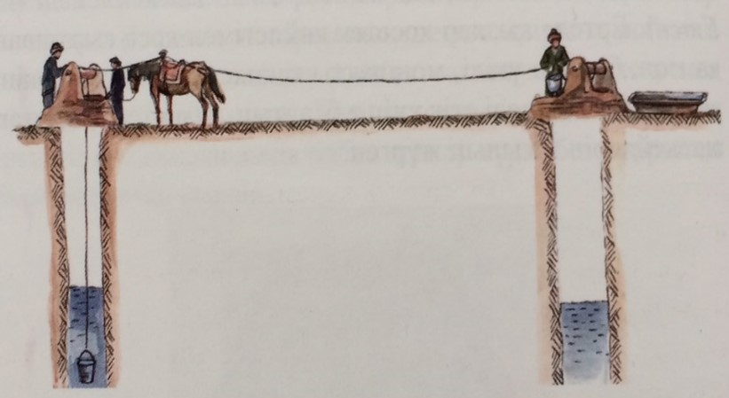
The pastoral route from Konyrat to Karakobda covers the Aral-Caspian region, which includes the southern and northwestern parts of the Aral Sea, the southern and northern Ustyurt Plateau, and Karakobda River area south of Aktobe. The Aral-Caspian lowlands include part of the vast Kazakh territories historically known as the “Turan Plain”. From a geopolitical perspective, the historical trade routes that connected the main historical and cultural regions of Central Asia, the Altai-Sayan region, the Caucasus, and Eastern Europe facilitated interaction between Europe and Asia. The history of routes through the deserts and arid ecosystems of the Aral-Caspian region has not been well studied. The routes in the Aral-Caspian region that connected Central Asia with the West were used during historical periods until the 1920s-1930s. Until the early 20th century, some medieval the first stop for caravans travelling from Khiva and Urgench. Depending on their direction and function, communication routes were classified as caravan or nomadic paths. In the study of toponyms related to seasonal pastures, such as Aksai, Ashyairyq, Tushyairyg, Kainar and Tasastau, along the Konyrat-Karakobda route through the Ustyurt, the location and preservation status of wells were documented. A section of the Konyrat-Karakobda route was part of the medieval caravan network through Mangystau and northwestern Ustyurt, intersecting with the branch linking Central Asia to Kyzyl-Kala and Ketik-Kala. Some medieval caravan routes were also used for herding livestock. The junctions where these routes branched out formed networks that were used not only for trade, but also for seasonal pastures. The southern section, from Konyrat to Karakobda, was known as the Kaskajol route. The etymology of wells names are important for documenting the history and culture of Kazakhstan. The Kazakh people have preserved traditional well-digging knowledge that is still practised today. Terms reflecting regional dialects, construction methods, personal names, landscape features and historical events play a key role in Kazakh ethnolinguistics. As well as serving as water sources, wells also acted as checkpoints along trade routes, while long-distance pastoral routes developed from the Kazakhs’ enduring coexistence with nature.
Downloads
Reference
Arnol'di M.V., 1885. V Zakasрiyskom krae v 1877 godu. Vospominaniya oficera. [Transcaspian region in 1877. Memories of an officer]. SPb.: Tipografiya Departamenta Udelov. 44 p. [in Russian].
Azhіgali S.E., 2015. Aktobe oblysynyn asa kornektі arhitekturalyk eskertkіshterі: fotokorme. [Outstanding architectural monuments of Aktobe region: photo exhibition. Scientific information publication]. Gylymi-akparattyk basylym. Almaty-Aktobe. 52 p. [in Kazakh, in Russian].
Belyaevskiy N.A., 1885. Put' ot zaliva Cesarevicha cherez Ust'-Urt do Kungrada. Sbornik geograficheskih, topograficheskih i statisticheskih materialov po Azii. [The route from Tsarevich Bay through Ust-Urt to Kungrad. Collection of geographical, topographic and statistical materials on Asia]. SPb.: Voennaya tipografiya. P. 1-89. [in Russian].
Budagov L.Z., 1871. Sravnitel'nyy slovar' turecko-tatarskih narechiy, so vklyucheniem upotrebitel'neyshih slov arabskih i persidskih i s perevodom na russkiy yazyk. [A comparative dictionary of Turkish-Tatar dialects, including the most common Arabic and Persian words and with a translation into Russian]. V.2. [K-N]. Sost. Lazar' Budagov. SPb.: tip. Imp. AN. 415 p. [in Russian].
Valihanov Ch.Ch., 1985. Sobranie sochineniy v pyati tomah. [Collected works in five volumes]. Tom 4. Alma-Ata: Glavnaya redakciya Kazahskoy sovetskoy yenciklopedii. 458 p. [in Russian].
Vyalov O.S., 1934. Kolodcy i istochniki Ustyurta. [Wells and springs of Ustyurt]. Izvestiya GGO. V. 6. No1. P.146-176. [in Russian].
Grodekov N.I., 1883. Hivinskiy pohod 1873 goda. Deystviya kavkazskih otryadov. [Khiva campaign of 1873. Actions of Caucasian detachments]. Sankt-Peterburg: Tip. V.S. Balashova. Izdanie redakcii istoricheskogo zhurnala «Russkaya starina». 345+65 p. http://militera.lib.ru/h/grodekov_ni/09.html (Date: 01.04.2025). [in Russian].
Edilhan A.M., 2013. O kolodcah Mangystau [About the wells of Mangystau]. Voprosy istorii i arheologii Zapadnogo Kazahstana. No1. P. 91-108. [in Russian].
Zhanbyrshyuly T., 2001. Men aytayyn – babannan [I speak on behalf of the ancestors]. Almaty: Ysh kiyan. 308 p. [in Kazakh].
Zalessky B., 1991. Kyrgyz Saharasyna Sayakhat. [La vie des Steppes Kirghizes, Journey to the Kyrgyz steppe]. Almaty: «Oner» baspasy. 132 p. [in Kazakh, in Russian].
Kazaktyn yetnografiyalyk kategoriyalar, ugymdar, ataularynyn dastyrlі zhyyesі [The Traditional system of ethnographical categories conceptions and designations of Kazakhs. Encyclopedia], 2017. 5 tomdyk yenciklopediya. V. 3, KRMOM. Almaty: Alem Damu Ingegraciya. 845 p. [in Kazakh].
Kazak tіlіnіn aymaktyk sozdіgі [Regional dictionary of the Kazakh language], 2005. Kurastyrgan: G.Kaliev, O.Nakysbekov, Sh.Sarybaev, A.Uderbaev zhane t.b. Almaty: Arys. 824 p. [in Kazakh].
Karutc R., 1911. Sredi kirgizov i turkmenov na Mangyshlake. Per s nem. E. Petri [Among the Kyrgyz and Turkmens in Mangyshlak. Translated from German by E. Petri]. SPb.: Izdanie A.F. Devrieva. 188 p. [in Russian].
Koychubaev E., 1974. Kratkiy tolkovyy slovar' toponimov Kazahstana [Brief explanatory dictionary of toponyms of Kazakhstan]. AN KazSSR. In-t yazykoznaniya. Alma-Ata: Nauka. 274 p [in Russian].
Konkashpaev G.K., 1963. Slovar' kazahskih geograficheskih nazvaniy [Dictionary of Kazakh geographical names]. Alma-Ata: AN.KazSSR. 184 p. [in Russian].
Koshimova B.A., 2010. Mangystau oniri zher-su ataularyn tusіndіrme sozdigi [Explanatory dictionary of place names of the Mangystau region]. Almaty: Nurly Alem. 238 p. [in Kazakh].
Levanevskiy M.A., 1894. Ocherki kirgizskih stepey Yembenskogo uezda. [Essays on the Kyrgyz steppes of the Embensky district]. Vyp. ІV. V.1. [in Russian].
Lomakin N.P., 1873. O poluostrove Mangyshlake i putyah ottuda v raznye punkty Zakaspiyskago kraya. [About the Mangyshlak Peninsula and the routes from there to various points in the Trans-Caspian region]. Zapiski Kavkazskago otdela IRGO. Kn. VIII. Tiflis. P. 1-42. [in Russian].
Mag-Gahan, 1875. Voennye deystviya na Oksuse i padenie Hivy. [Military operations on the Oxus and the fall of Khiva]. Moscow: Universitetskaya tipografiya Katkov i K. 304 p. [in Russian].
Manylov Yu.P., Yusupov N.Yu., 1982. Caravanserai Tsentralnogo Ustyurta (v predelah Karakalpak ASSR) [Caravanserai of Central Ustyurt (within the Karakalpak ASSR)]. Soviet archaeology. No. 1. P. 170-182. [in Russian].
Margulan A.Kh., 1949. Drevnie karavannye puti cherez pustynyu Betpak dala [Ancient caravan routes through the Betpak-Dala desert]. Vestnik Akademii nauk KazSSR. Almaty. P. 68-77. [in Russian].
Mahmud Kashkari, 1997. Tyrіk tіlіnіn sozdіgі (Diuani lugat-it-tyrіk) [Dictionary of Turkic dialects]. 3 tomdyk. Almaty: Hant. 528 р. [in Kazakh].
Mukanov S., 1974. Tandamaly shygarmalar. [Collection of works] 16 tomdyk. Vol.15. Halyk murasy. Almaty: Kazakstan. 236 p. [in Kazakh].
Rychkov N.P., 1772. Dnevnye zapiski puteshestviya kapitana Nikolaya Rychkova v kirgiz-kajsackoj stepi v 1771 g. [Daily notes of the journey of captain Nikolai Rychkov in the Kyrgyz-Kaisak steppe in 1771]. SPb. 104 p. [in Russian].
Hozyaystvo kazahov na rubezhe XІX-XX vekov, 1980. Materialy k istoriko-yetnograficheskomu atlasu [Economy of the Kazakhs at the turn of the 19th-20th centuries. Materials for the historical and ethnographic atlas]. Alma-Ata: Nauka. 256 p. + 4 karta. [in Russian].
Yeversman Ye.A., 1840. Estestvennaya istoriya Orenburskogo kraya [Natural history of the Orenburg region]. Volume 1. Orenburg. 413 p. [in Russian].
Downloads
Published
How to Cite
Issue
Section
License
Copyright (c) 2025 Turkic Studies Journal

This work is licensed under a Creative Commons Attribution-NonCommercial 4.0 International License.